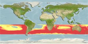
You can sponsor this page

Allothunnus fallai Serventy, 1948

Slender tuna
مشاهدات خود را اضافه کنيد در Fish Watcher
Native range | All suitable habitat | Point map | Year 2050
This map was computer-generated and has not yet been reviewed.
Allothunnus fallai   AquaMaps   Data sources: GBIF OBIS
را بارگذاری کني تصاوير و فيلم ها
Pictures | تصوير گوگل
Image of Allothunnus fallai (Slender tuna)
Allothunnus fallai
Picture by FAO

Common names from other countries

رده بندی / Names اسامي عام | مترادف | Catalog of Fishes(جنس, گونه ها) | ITIS | CoL | WoRMS | Cloffa

> Scombriformes (Mackerels) > Scombridae (Mackerels, tunas, bonitos) > Scombrinae
Etymology: Allothunnus: Greek, allos = other + Greek, thynnos = tunna (Ref. 45335).

Environment: milieu / climate zone / depth range / distribution range بوم شناسي

دريايي; اقیانوس رو (Ref. 51243); تغييرات عمق 0 - 20 m (Ref. 86942).   Subtropical; 10°S - 50°S, 180°W - 180°E (Ref. 168)

پراكنش كشورها | مناطق سازمان خوار و بار جهاني (FAO) | Ecosystems | ظهور |
Fatal error: Uncaught mysqli_sql_exception: Table 'fbapp.scientificname' doesn't exist in /var/www/html/includes/speciessummary.lib.php:2366 Stack trace: #0 /var/www/html/includes/speciessummary.lib.php(2366): mysqli->query() #1 /var/www/html/country/CountrySpeciesSummary.php(1228): checkPointMApDisplay() #2 {main} thrown in /var/www/html/includes/speciessummary.lib.php on line 2366