You can
sponsor
this page
Common name (e.g. trout)
contains
begins with
begins with
ends with
is
Genus + Species (e.g. Gadus morhua)
このページについて
More Info
Plus d'info
Mais info
言語
Arabic
Bahasa/Malay
Bangla
Chinese(Si)
Chinese(Tr)
Deutsch
English
Español
Farsi
Français
Greek
Hindi
Italiano
Japanese
Lao
Nederlands
Português(Br)
Português(Pt)
Russian
Swedish
Thai
Vietnamese
User feedbacks
Comments &
Corrections
魚のフォーラム
ゲストブック
Facebook
引用
Uploads
ウェブサイトを付け加えて下さい
写真をアップロード
ビデオをアップロード
Upload
references
Fish Watcher
近縁種
種
Gadus
種
Gadidae
- 分類 -
Gadidae
Gadiformes
Teleostei
Chordata
Animalia
Gadus
morhua
Linnaeus
, 1758
Atlantic cod
個人による観察記録の追加
Fish Watcher
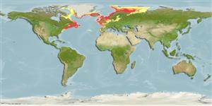
Native range
|
All suitable habitat
|
Point map
|
Year 2050
This map was computer-generated and has not yet been reviewed.
Gadus morhua
AquaMaps
Data sources:
GBIF
OBIS
Upload your
写真
and
ビデオ
Pictures
|
Videos |
Sounds
|
Stamps, Coins Misc.
|
グーグルの画像
Gadus morhua
Picture by
Morris, P.
United States (contiguous states) country information
Common names:
Atlantic cod
,
Cod
,
Codfish brick
Occurrence:
native
Salinity:
brackish
Abundance:
|
Ref:
Importance:
commercial
|
Ref:
FAO, 1994
Aquaculture:
|
Ref:
Regulations:
|
Ref:
Uses:
no uses
Comments:
Present in the continental shelf waters off the northeastern United States (Ref. 37512); Chesapeake Bay (Ref. 93252, 27549).
National Checklist:
Country Information:
https://www.cia.gov/library/publications/resources/the-world-factbook/geos/us.html
National Fisheries Authority:
http://www.nmfs.gov
Occurrences:
Occurrences
Point map
Main Ref:
Cohen, D.M., T. Inada, T. Iwamoto and N. Scialabba, 1990
National Database:
Common names from other countries
Morue de l'Atlantique
,
Bacalao del Atlántico
,
大西洋鳕
,
... more
分類 / Names
共通名の
|
類義語
| Catalog of Fishes(
部類
,
種
) |
ITIS
|
CoL
|
WoRMS
|
Cloffa
>
Gadiformes
(Cods) >
Gadidae
(Cods and haddocks)
Etymology:
Gadus:
Latin, gadus = a fish, cod? (Ref.
45335
)
.
More on author:
Linnaeus
.
Environment: milieu / climate zone / depth range / distribution range
生態学
海
; 汽水性の
底生の漂泳性; 海洋回遊性 (Ref.
51243
);
深さの範囲
0 - 600 m (Ref.
1371
), usually 150 - 200 m (Ref.
54441
). Temperate; 0°C - 15°C; 83°N - 35°N, 76°W - 86°E (Ref.
1371
)
分布
国々
|
国連食糧農業機関の区域
|
エコシステム
|
事件
|
Fatal error
: Uncaught mysqli_sql_exception: Table 'fbapp.scientificname' doesn't exist in /var/www/html/includes/speciessummary.lib.php:2366 Stack trace: #0 /var/www/html/includes/speciessummary.lib.php(2366): mysqli->query() #1 /var/www/html/country/CountrySpeciesSummary.php(1228): checkPointMApDisplay() #2 {main} thrown in
/var/www/html/includes/speciessummary.lib.php
on line
2366

")
