You can
sponsor
this page
Common name (e.g. trout)
contains
begins with
begins with
ends with
is
Genus + Species (e.g. Gadus morhua)
このページについて
More Info
Plus d'info
Mais info
言語
Arabic
Bahasa/Malay
Bangla
Chinese(Si)
Chinese(Tr)
Deutsch
English
Español
Farsi
Français
Greek
Hindi
Italiano
Japanese
Lao
Nederlands
Português(Br)
Português(Pt)
Russian
Swedish
Thai
Vietnamese
User feedbacks
Comments &
Corrections
魚のフォーラム
ゲストブック
Facebook
引用
Uploads
ウェブサイトを付け加えて下さい
写真をアップロード
ビデオをアップロード
Upload
references
Fish Watcher
近縁種
種
Micromesistius
種
Gadidae
- 分類 -
Gadidae
Gadiformes
Teleostei
Chordata
Animalia
Micromesistius
poutassou
(Risso
, 1827)
Blue whiting
個人による観察記録の追加
Fish Watcher
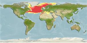
Native range
|
All suitable habitat
|
Point map
|
Year 2050
This map was computer-generated and has not yet been reviewed.
Micromesistius poutassou
AquaMaps
Data sources:
GBIF
OBIS
Upload your
写真
and
ビデオ
Pictures
|
グーグルの画像
Micromesistius poutassou
Picture by
Svensen, R.
Common names from other countries
Merlan bleu
,
Bacaladilla
,
غُبَر أزرق
,
... more
分類 / Names
共通名の
|
類義語
| Catalog of Fishes(
部類
,
種
) |
ITIS
|
CoL
|
WoRMS
|
Cloffa
>
Gadiformes
(Cods) >
Gadidae
(Cods and haddocks)
Etymology:
Micromesistius:
Greek, mikros = small + greek, mesos = middle + Greek, istion = sail (Ref.
45335
)
.
More on author:
Risso
.
Environment: milieu / climate zone / depth range / distribution range
生態学
海
深海浮遊性; 海洋回遊性 (Ref.
51243
);
深さの範囲
150 - 3000 m (Ref.
3663
), usually 300 - 400 m. Temperate; 79°N - 26°N, 82°W - 51°E (Ref.
1371
)
分布
国々
|
国連食糧農業機関の区域
|
エコシステム
|
事件
|
Fatal error
: Uncaught mysqli_sql_exception: Table 'fbapp.scientificname' doesn't exist in /var/www/html/includes/speciessummary.lib.php:2366 Stack trace: #0 /var/www/html/includes/speciessummary.lib.php(2366): mysqli->query() #1 /var/www/html/country/CountrySpeciesSummary.php(1228): checkPointMApDisplay() #2 {main} thrown in
/var/www/html/includes/speciessummary.lib.php
on line
2366

")
