Environment: milieu / climate zone / depth range / distribution range
بوم شناسي
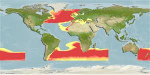
دريايي ناحیه ای از منطقه اقیانوسی با عمق بین 1000 تا 4000 متر. موجوداتی که در آبهای آزاد بین اعماق 1000 تا 4000 متر زندگی و تغذیه می کنند; تغييرات عمق 40 - 1050 m (Ref. 52180), usually 300 - 700 m (Ref. 52180). Deep-water; 68°N - 55°S, 180°W - 180°E
پراكنش
كشورها | مناطق سازمان خوار و بار جهاني (FAO) | Ecosystems | ظهور | Fatal error: Uncaught mysqli_sql_exception: Table 'fbapp.scientificname' doesn't exist in /var/www/html/includes/speciessummary.lib.php:2366
Stack trace:
#0 /var/www/html/includes/speciessummary.lib.php(2366): mysqli->query()
#1 /var/www/html/country/CountrySpeciesSummary.php(1228): checkPointMApDisplay()
#2 {main}
thrown in /var/www/html/includes/speciessummary.lib.php on line 2366

")
