United States (contiguous states) country information
Common names:
Alewife, Bigeye herring, Branch herring
Occurrence:
native
Salinity:
freshwater
Abundance:
abundant (always seen in some numbers)
|
Ref: Page, L.M. and B.M. Burr, 2011
Importance:
minor commercial
|
Ref: FAO, 1994
Aquaculture:
|
Ref:
Regulations:
|
Ref:
Uses:
no uses
Comments:
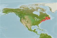
Known from the Atlantic coast from Maine to South Carolina (Ref. 86798). Present in the continental shelf waters off the northeastern United States (Ref. 37512, 10294). Introduced elsewhere, including New River in West Virginia and Virginia, and upper Tennessee River system in Tennessee (Ref. 86798). Virtually all streams tributary to Chesapeake Bay; also found in Virginia, Delaware, and New Jersey (Ref. 4639). Usually abundant, although dams obstruct migrations (Ref. 86798). Also Ref. 188, 27549, 93252, 10294.
National Checklist:
Country Information:
https://www.cia.gov/library/publications/resources/the-world-factbook/geos/us.html
National Fisheries Authority:
http://www.nmfs.gov
Occurrences:
OccurrencesPoint map
Main Ref:
Page, L.M. and B.M. Burr, 2011
National Database:
Teleostei > Clupeiformes (Herrings) > Alosidae (Shads and Sardines)
Etymology: Alosa:Latin, alausa = a fish cited by Ausonius and Latin, halec = pickle, dealing with the Greek word hals = salt; it is also the old Saxon name for shad = "alli" ; 1591 (Ref. 45335); pseudoharengus:From the words pseudo, meaning false and harengus, meaning herring (Ref. 10294).
Environment: milieu / climate zone / depth range / distribution range
生态学
海洋; 淡水; 半咸淡水; 溯河洄游 (Ref. 51243); 深度上下限 5 - 145 m (Ref. 4639), usually 56 - 110 m (Ref. 5951). 溫帶; 55°N - 34°N, 93°W - 53°W (Ref. 86798)
分布
国家 | FAO区域 | 生态系 | 标本纪录 | Fatal error: Uncaught mysqli_sql_exception: Table 'fbapp.scientificname' doesn't exist in /var/www/html/includes/speciessummary.lib.php:2366
Stack trace:
#0 /var/www/html/includes/speciessummary.lib.php(2366): mysqli->query()
#1 /var/www/html/country/CountrySpeciesSummary.php(1228): checkPointMApDisplay()
#2 {main}
thrown in /var/www/html/includes/speciessummary.lib.php on line 2366


")