You can
sponsor
this page
Common name (e.g. trout)
contains
begins with
begins with
ends with
is
Genus + Species (e.g. Gadus morhua)
Sobre essa página
More Info
Plus d'info
Mais info
Línguas
Arabic
Bahasa/Malay
Bangla
Chinese(Si)
Chinese(Tr)
Deutsch
English
Español
Farsi
Français
Greek
Hindi
Italiano
Japanese
Lao
Nederlands
Português(Br)
Português(Pt)
Russian
Swedish
Thai
Vietnamese
User feedbacks
Comments &
Corrections
Fórum sobre peixes
Livro de convidados
Facebook
Citação
Uploads
Adicionar website
Carregar foto
Carregar vídeo
Upload
references
Fish Watcher
Espécies relacionadas
Espécie em
Allothunnus
Espécie em
Scombridae
- Classificação -
Scombrinae
Scombridae
Scombriformes
Teleostei
Chordata
Animalia
Allothunnus
fallai
Serventy
, 1948
Slender tuna
Adicionar sua observação em
Fish Watcher
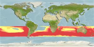
Native range
|
All suitable habitat
|
Point map
|
Year 2050
This map was computer-generated and has not yet been reviewed.
Allothunnus fallai
AquaMaps
Data sources:
GBIF
OBIS
Carregue seu(sua)
Fotos
e
vídeos
Pictures
|
Imagem do Google
Allothunnus fallai
Picture by
FAO
Common names from other countries
Thon élégant
,
Atún lanzón
,
Тунец южный
,
... more
Classificação / Names
Nomes comuns
|
Sinônimos
| Catalog of Fishes(
Gênero
,
Espécies
) |
ITIS
|
CoL
|
WoRMS
|
Cloffa
>
Scombriformes
(Mackerels) >
Scombridae
(Mackerels, tunas, bonitos) > Scombrinae
Etymology:
Allothunnus:
Greek, allos = other + Greek, thynnos = tunna (Ref.
45335
)
.
Environment: milieu / climate zone / depth range / distribution range
Ecologia
marinhas
; oceanódromo (Ref.
51243
);
intervalo de profundidade
0 - 20 m (Ref.
86942
). Subtropical; 10°S - 50°S, 180°W - 180°E (Ref.
168
)
Distribuição
Países
|
Áreas da FAO
|
Ecossistemas
|
Ocorrências
|
Fatal error
: Uncaught mysqli_sql_exception: Table 'fbapp.scientificname' doesn't exist in /var/www/html/includes/speciessummary.lib.php:2366 Stack trace: #0 /var/www/html/includes/speciessummary.lib.php(2366): mysqli->query() #1 /var/www/html/country/CountrySpeciesSummary.php(1228): checkPointMApDisplay() #2 {main} thrown in
/var/www/html/includes/speciessummary.lib.php
on line
2366

")
