You can sponsor this page

Photocorynus spiniceps Regan, 1925

Add your observation in Fish Watcher
Native range | All suitable habitat | Point map | Year 2050
This map was computer-generated and has not yet been reviewed.
Photocorynus spiniceps   AquaMaps   Data sources: GBIF OBIS
Upload your photos and videos
Pictures | Google image
Image of Photocorynus spiniceps
Photocorynus spiniceps
Female picture by Pietsch, T.W.


Panama country information

Common names: [No common name]
Occurrence: native
Salinity: marine
Abundance: | Ref:
Importance: | Ref:
Aquaculture: | Ref:
Regulations: | Ref:
Uses: no uses
Comments: Type locality: Gulf of Panama, 7°15'N, 78°54'W, ca. 1250 m. (Ref. 26282). Also Ref. 86949.
National Checklist:
Country Information: https://www.cia.gov/library/publications/resources/the-world-factbook/geos/pm.html
National Fisheries Authority:
Occurrences: Occurrences Point map
Main Ref: Eschmeyer, W.N. (ed.), 1998
National Database:

Common names from other countries

Classification / Names Common names | Synonyms | Catalog of Fishes(genus, species) | ITIS | CoL | WoRMS | Cloffa

Teleostei (teleosts) > Lophiiformes (Anglerfishes) > Linophrynidae (Leftvents)
Etymology: Photocorynus: Greek, 'phos' or 'photos' = light + Greek, 'koryne' = club or mace (alluding to the unusually short and clublike illicium and esca of the genus) (Ref. 86949).
  More on author: Regan.

Environment: milieu / climate zone / depth range / distribution range Ecology

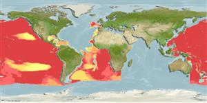
Marine; bathypelagic; depth range 990 - 1420 m (Ref. 86949).   Deep-water

Distribution Countries | FAO areas | Ecosystems | Occurrences |
Fatal error: Uncaught mysqli_sql_exception: Table 'fbapp.scientificname' doesn't exist in /var/www/html/includes/speciessummary.lib.php:2366 Stack trace: #0 /var/www/html/includes/speciessummary.lib.php(2366): mysqli->query() #1 /var/www/html/country/CountrySpeciesSummary.php(1228): checkPointMApDisplay() #2 {main} thrown in /var/www/html/includes/speciessummary.lib.php on line 2366