You can
sponsor
this page
Common name (e.g. trout)
contains
begins with
begins with
ends with
is
Genus + Species (e.g. Gadus morhua)
このページについて
More Info
Plus d'info
Mais info
言語
Arabic
Bahasa/Malay
Bangla
Chinese(Si)
Chinese(Tr)
Deutsch
English
Español
Farsi
Français
Greek
Hindi
Italiano
Japanese
Lao
Nederlands
Português(Br)
Português(Pt)
Russian
Swedish
Thai
Vietnamese
User feedbacks
Comments &
Corrections
魚のフォーラム
ゲストブック
Facebook
引用
Uploads
ウェブサイトを付け加えて下さい
写真をアップロード
ビデオをアップロード
Upload
references
Fish Watcher
近縁種
Hyperoglyphe antarctica
種
Hyperoglyphe
種
Centrolophidae
- 分類 -
Centrolophidae
Scombriformes
Teleostei
Chordata
Animalia
Hyperoglyphe
antarctica
(Carmichael
, 1819)
Bluenose warehou
個人による観察記録の追加
Fish Watcher
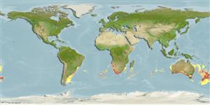
Native range
|
All suitable habitat
|
Point map
|
Year 2050
This map was computer-generated and has not yet been reviewed.
Hyperoglyphe antarctica
AquaMaps
Data sources:
GBIF
OBIS
Upload your
写真
and
ビデオ
Pictures
|
グーグルの画像
Hyperoglyphe antarctica
Picture by
SeaFIC
New Zealand country information
Common names:
Bluenose
,
Matiri
Occurrence:
native
Salinity:
marine
Abundance:
|
Ref:
Importance:
commercial
|
Ref:
Aquaculture:
|
Ref:
Regulations:
|
Ref:
Uses:
no uses
Comments:
Recorded in the trawl survey in Chatham Islands (Ref. 45493). Also recorded from bottom trawls off the east coast of South Island (Ref. 58461). Voucher specimen(s) held at the NMNZ. Also Ref. 9072, 9258.
National Checklist:
Country Information:
https://www.cia.gov/library/publications/resources/the-world-factbook/geos/nz.html
National Fisheries Authority:
http://www.fish.govt.nz/
Occurrences:
Occurrences
Point map
Main Ref:
Paulin, C., A. Stewart, C. Roberts and P. McMillan, 1989
National Database:
Common names from other countries
Rouffe antarctique
,
Rufo antártico
,
خزّان مَزرورق
,
... more
分類 / Names
共通名の
|
類義語
| Catalog of Fishes(
部類
,
種
) |
ITIS
|
CoL
|
WoRMS
|
Cloffa
>
Scombriformes
(Mackerels) >
Centrolophidae
(Medusafishes)
Etymology:
Hyperoglyphe:
Greek, hyper = over + Greek, glyphis = carved (Ref.
45335
)
.
Environment: milieu / climate zone / depth range / distribution range
生態学
海
底生の漂泳性;
深さの範囲
40 - 1500 m (Ref.
52180
), usually 260 - 490 m (Ref.
52180
). Deep-water; 19°S - 55°S, 67°W - 173°W
分布
国々
|
国連食糧農業機関の区域
|
エコシステム
|
事件
|
Fatal error
: Uncaught mysqli_sql_exception: Table 'fbapp.scientificname' doesn't exist in /var/www/html/includes/speciessummary.lib.php:2366 Stack trace: #0 /var/www/html/includes/speciessummary.lib.php(2366): mysqli->query() #1 /var/www/html/country/CountrySpeciesSummary.php(1228): checkPointMApDisplay() #2 {main} thrown in
/var/www/html/includes/speciessummary.lib.php
on line
2366


")