You can sponsor this page

Thyrsites atun (Euphrasen, 1791)

Snoek
個人による観察記録の追加 Fish Watcher
Native range | All suitable habitat | Point map | Year 2050
This map was computer-generated and has not yet been reviewed.
Thyrsites atun   AquaMaps   Data sources: GBIF OBIS
Upload your 写真 and ビデオ
Pictures | グーグルの画像
Image of Thyrsites atun (Snoek)
Thyrsites atun
Picture by Le Noury, P.


Chile country information

Common names: Sierra, Sierra comun
Occurrence: native
Salinity: marine
Abundance: | Ref:
Importance: minor commercial | Ref: Nakamura, I. and N.V. Parin, 1993
Aquaculture: | Ref:
Regulations: | Ref:
Uses: no uses
Comments: Recorded from the Juan Fernández Islands (Ref. 33693). Also Ref. 5530, 9068, 9988, 27363.
National Checklist:
Country Information: https://www.cia.gov/library/publications/resources/the-world-factbook/geos/ci.html
National Fisheries Authority:
Occurrences: Occurrences Point map
Main Ref: Nakamura, I. and N.V. Parin, 1993
National Database:

Common names from other countries

分類 / Names 共通名の | 類義語 | Catalog of Fishes(部類, ) | ITIS | CoL | WoRMS | Cloffa

> Scombriformes (Mackerels) > Gempylidae (Snake mackerels)
Etymology: Thyrsites: Greek, thyrsites, -ou = stalk of a plant, an ornament like a pine cone borne by Bacchus (Ref. 45335).

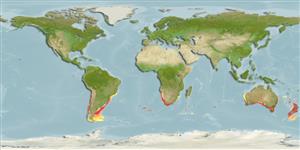
Environment: milieu / climate zone / depth range / distribution range 生態学

; 汽水性の 底生の漂泳性; 海洋回遊性; 深さの範囲 0 - 550 m (Ref. 6390), usually 100 - 500 m (Ref. 6181).   Subtropical; 13°C - 18°C (Ref. 6181); 21°S - 56°S, 75°W - 177°E (Ref. 54924)

分布 国々 | 国連食糧農業機関の区域 | エコシステム | 事件 |
Fatal error: Uncaught mysqli_sql_exception: Table 'fbapp.scientificname' doesn't exist in /var/www/html/includes/speciessummary.lib.php:2366 Stack trace: #0 /var/www/html/includes/speciessummary.lib.php(2366): mysqli->query() #1 /var/www/html/country/CountrySpeciesSummary.php(1228): checkPointMApDisplay() #2 {main} thrown in /var/www/html/includes/speciessummary.lib.php on line 2366