You can
sponsor
this page
Common name (e.g. trout)
contains
begins with
begins with
ends with
is
Genus + Species (e.g. Gadus morhua)
About this page
More Info
Plus d'info
Mais info
Languages
Arabic
Bahasa/Malay
Bangla
Chinese(Si)
Chinese(Tr)
Deutsch
English
Español
Farsi
Français
Greek
Hindi
Italiano
Japanese
Lao
Nederlands
Português(Br)
Português(Pt)
Russian
Swedish
Thai
Vietnamese
User feedbacks
Comments &
Corrections
ບ່ອນແລກປ່ຽນຄວາມຄິດເຫັນກ່ຽວກັບປາ
ປື້ມບັນທຶກຜູ້ເຂົ້າເວັບ
Facebook
ການຂຽນກ່າວອ້າງ
Uploads
Attach website
Upload photo
Upload video
Upload
references
Fish Watcher
Related species
Species in
Bothus
Species in
Bothidae
- Classification -
Bothidae
Pleuronectiformes
Teleostei
Chordata
Animalia
Bothus
robinsi
Topp
&
Hoff
, 1972
Twospot flounder
Add your observation in
Fish Watcher
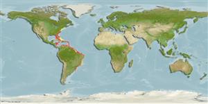
Native range
|
All suitable habitat
|
Point map
|
Year 2050
This map was computer-generated and has not yet been reviewed.
Bothus robinsi
AquaMaps
Data sources:
GBIF
OBIS
Upload your
photos
and
videos
Pictures
|
Google image
Bothus robinsi
Picture by
NOAA\NMFS\Mississippi Laboratory
Bahamas country information
Common names:
Spottail flounder
Occurrence:
native
Salinity:
marine
Abundance:
|
Ref:
Importance:
|
Ref:
Aquaculture:
|
Ref:
Regulations:
|
Ref:
Uses:
no uses
Comments:
Known from the Green Cay and the Nassau area on the Great Bahama Bank.
National Checklist:
Country Information:
https://www.cia.gov/library/publications/resources/the-world-factbook/geos/bf.html
National Fisheries Authority:
http://www.caricom-fisheries.com/bahamas-fisheries
Occurrences:
Occurrences
Point map
Main Ref:
Böhlke, J.E. and C.C.G. Chaplin, 1993
National Database:
Common names from other countries
Spottail flounder
,
Chueco dos manchas
,
Linguado
,
... more
Classification / Names
ຊື່ສາມັນ
|
ຄຳສັບຄ້າຍຄືກັນ
| Catalog of Fishes(
ຕະກຸນ
,
ຊະນິດ
) |
ITIS
|
CoL
|
WoRMS
|
Cloffa
>
Pleuronectiformes
(Flatfishes) >
Bothidae
(Lefteye flounders)
Etymology:
Environment: milieu / climate zone / depth range / distribution range
ນິເວດວິທະຍາ
ສັດທະເລ
ອາໄສຢູ່ໃກ້ໜ້າດິນໃຕ້ພື້ນທ້ອງນ້ຳ;
ລະດັບຄວາມເລິກ
1 - 90 m (Ref.
5217
), usually 10 - 50 m (Ref.
5217
). Tropical; 41°N - 33°S, 85°W - 34°W
ການແຜ່ກະຈາຍ
ປະເທດ
|
ເຂດ FAO
|
ລະບົບນິເວດ
|
ການປະກົດຕົວ
|
Fatal error
: Uncaught mysqli_sql_exception: Table 'fbapp.scientificname' doesn't exist in /var/www/html/includes/speciessummary.lib.php:2366 Stack trace: #0 /var/www/html/includes/speciessummary.lib.php(2366): mysqli->query() #1 /var/www/html/country/CountrySpeciesSummary.php(1228): checkPointMApDisplay() #2 {main} thrown in
/var/www/html/includes/speciessummary.lib.php
on line
2366

")
