You can
sponsor
this page
Common name (e.g. trout)
contains
begins with
begins with
ends with
is
Genus + Species (e.g. Gadus morhua)
About this page
More Info
Plus d'info
Mais info
Languages
Arabic
Bahasa/Malay
Bangla
Chinese(Si)
Chinese(Tr)
Deutsch
English
Español
Farsi
Français
Greek
Hindi
Italiano
Japanese
Lao
Nederlands
Português(Br)
Português(Pt)
Russian
Swedish
Thai
Vietnamese
User feedbacks
Comments &
Corrections
เวทีแลกเปลี่ยนความคิดเห็นเกี่ยวกับปลา
สมุดเยี่ยม
Facebook
การอ้างอิง
Uploads
Attach website
Upload photo
Upload video
Upload
references
Fish Watcher
Related species
Species in
Etrumeus
Species in
Dussumieriidae
- Classification -
Dussumieriidae
Clupeiformes
Teleostei
Chordata
Animalia
Etrumeus
whiteheadi
Wongratana
, 1983
Whitehead's round herring
Add your observation in
Fish Watcher
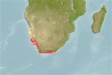
Native range
|
All suitable habitat
|
Point map
|
Year 2050
This map was computer-generated and has not yet been reviewed.
Etrumeus whiteheadi
AquaMaps
Data sources:
GBIF
OBIS
Upload your
photos
and
videos
Pictures
|
Google image
Etrumeus whiteheadi
Picture by
FAO
Angola country information
Common names:
[No common name]
Occurrence:
native
Salinity:
marine
Abundance:
|
Ref:
Importance:
|
Ref:
Aquaculture:
|
Ref:
Regulations:
|
Ref:
Uses:
no uses
Comments:
Known up to southern Angola.
National Checklist:
Country Information:
https://www.cia.gov/library/publications/resources/the-world-factbook/geos/ao.html
National Fisheries Authority:
Occurrences:
Occurrences
Point map
Main Ref:
DiBattista, J.D., J.E. Randall and B.W. Bowen, 2012
National Database:
Common names from other countries
Shadine de Angola
,
Sardina angoleña
,
Etrumeus whiteheadův
,
... more
Classification / Names
ชื่อสามัญ
|
ชื่อพ้อง
| Catalog of Fishes(
สกุล
,
ชนิด
) |
ITIS
|
CoL
|
WoRMS
|
Cloffa
>
Clupeiformes
(Herrings) >
Dussumieriidae
(Round herrings)
Etymology:
Environment: milieu / climate zone / depth range / distribution range
นิเวศวิทยา
เกี่ยวกับทะเล,น้ำเค็ม
;
ระดับความลึก
0 - 200 m (Ref.
5286
). Subtropical; 23°S - 35°S, 12°E - 31°E
การแพร่กระจาย
ประเทศต่างๆ
|
พื้นที่จำแนกตาม FAO
|
ระบบนิเวศหลายระบบ
|
การปรากฏขึ้น,การเกิดขึ้น,พบ
|
Fatal error
: Uncaught mysqli_sql_exception: Table 'fbapp.scientificname' doesn't exist in /var/www/html/includes/speciessummary.lib.php:2366 Stack trace: #0 /var/www/html/includes/speciessummary.lib.php(2366): mysqli->query() #1 /var/www/html/country/CountrySpeciesSummary.php(1228): checkPointMApDisplay() #2 {main} thrown in
/var/www/html/includes/speciessummary.lib.php
on line
2366